The ongoing legal and ethical battle over seismic blasting and offshore exploration along the Wild Coast is often framed as a conflict between "development" and "conservation." This is a false dichotomy. When one looks at the hard data, it becomes clear that this is not a debate about development, but about a reckless gamble with odds that no actuary would accept.
Proponents of the exploration, including the Department of Mineral Resources and Energy, tout the "multi-billion barrel potential" of the Transkei and Algoa basins as a cure-all for South Africa’s energy woes. However, we must contextualize these numbers against reality.
The world currently consumes approximately 100 million barrels of oil per day. If explorers were to find a "giant" field of one billion recoverable barrels—a massive geological success by any standard it would sustain global consumption for merely ten days. We are being asked to risk the permanent integrity of one of the world's most biodiverse marine environments for a resource yield that constitutes a statistical drop in the global ocean.
Financially, the public is being misled. The heralded "20% State stake" is not a windfall; under the Upstream Petroleum Resources Development Act, it is effectively a loan. The State’s share of the massive infrastructure costs is "carried" by the oil majors, meaning we must pay them back from future revenues before seeing a cent. Furthermore, royalties are calculated on profitability, not just revenue. By amortizing the billions spent on deepwater rigs, operators can legally suppress royalty payments to the statutory minimum of 0.5% for years. We are mortgaging our coastline for a return that may barely exceed a rounding error.
The physical risks are equally understated. The Transkei Basin is not the North Sea or the Gulf of Mexico. It sits in the path of the Agulhas Current, the strongest western boundary current in the Southern Hemisphere. Oceanographers have long documented the phenomenon where this southwest-flowing current collides with strong south-westerly winds, creating "rogue waves" that can exceed 30 meters in height. These are not 1-in-100-year anomalies; in the Agulhas stream, they are a predictable feature. To station floating or fixed-rig infrastructure in such a volatile hydrodynamic zone is to invite catastrophe.
We are facing a scenario where short-term, speculative profits, which often evaporate into the pockets of multinational shareholders and a connected few, are prioritized over the sustainable, long-term economy of our coastal communities. The eco-tourism and fishing sectors provide livelihoods that last generations. An oil rig, even if it survives the waves, offers us only a fleeting extension of fossil fuels in an insane world that should be focusing on renewable resources.
It is time to look at the facts, acknowledge the financial and physical dangers, and accept that the Transkei Basin is the wrong place for this old 'fossil' industry.
Resource curse / extractive economy
Proponents claim that it will provide a significant contribution to South Africa’s energy requirements. However, estimates indicate South Africa currently imports over 90% of its refined fuel products.
Jet A1 and diesel are the biggest imports and the lifeblood of industry AND Eskom which relies far more heavily on OCGT than we are led to believe.
SAPREF (Durban): The largest refinery (formerly Shell/BP) is shut down. The state bought it for R1 to "save" it, but it remains inactive.
ENREF (Durban): Shut down and being converted into a storage terminal.
PetroSA (Mossel Bay): The Gas-to-Liquids plant is largely idle due to lack of feedstock.
The Pipeline Problem:
To bring gas from the Transkei Basin to the nearest industrial zones (Coega in Gqeberha or Richards Bay), would optimally require hundreds of kilometers of subsea or overland pipelines.
Given the "hundred-year waves" and the Agulhas Current, building and maintaining a subsea pipeline on the "Wild Coast" is technically perilous and prohibitively expensive.
The likely Model for deepwater fields in rough oceans is typically an FPSO (Floating Production, Storage, and Offloading) vessel.
This floating 'rig' pipes the oil/gas, stores it on board, and offloads it directly onto visiting tankers.
The oil never touches South African soil as we have no capacity left to refine it. It goes from the rig straight to an international refinery. The gas could be shipped to Coega.
While the Coega SEZ (Special Economic Zone) has plans for a 1000MW gas-to-power plant, they are currently looking at importing LNG (Liquefied Natural Gas) to run it because there is no way to get domestic gas there. Yet.
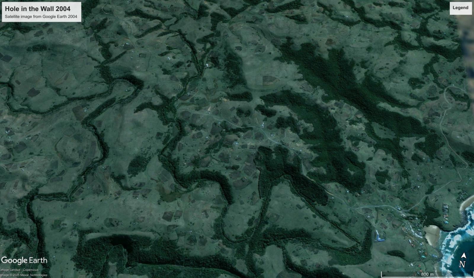
Landscape & Population Transformation: Mthonjana 2004 – 2022
A comparative analysis of the Mthonjana and Mgxotyeni hinterland reveals a profound shift in the demographic fabric of the Wild Coast. By dividing the region into eight distinct sectors, we have confirmed a structural explosion that has transitioned this region from a sparse subsistence landscape into a dense residential corridor.
Baseline Status (2004)
Observed Growth (2022)
Evidence of Dwelling Explosion: 8-Sector Audit
To ensure accuracy across varied topography, the study area was audited across eight sectors. This count includes traditional rondavels (huts), informal structures, and modern rectangular RDP houses ("Little boxes made of ticky tacky and they all look just the same"). The data confirms an aggressive transition to "ribbon development" following transport corridors and hill contours.
Sector & Primary Anchor
2004 Est. Dwellings
2022 Est. Dwellings
Growth Factor
North-West (School Node)
12
75+
~625%
North-Central (Upper Ridge)
18
80+
~440%
North-East (Inland Valley)
15
45+
~300%
West-Central (Main Access Road)
22
110+
~500%
Central (The S-Bend)
25
115+
~460%
East-Central (Secondary Ridge)
20
65+
~325%
South-West (Lower Slopes)
18
60+
~330%
South-East (Hole in the Wall / School node)
20
90+
~450%
Aggregate Region Total
~150
~640+
426% Structural Increase
Adjusted Community Dwellings*
~110
~600
550% (5.5x) Growth Factor
* Note: The estimate excludes ±40 holiday cottages and hotel units that remain largely unoccupied year-round.
Note on Population Estimation
The increase in dwellings and anecdotal evidence suggests a population surge from ~600 in 2004 to over 2,500 residents today.
The number is a conservative estimate based on four people per dwelling (a couple + two children). The true human density is likely higher due to the following local realities:
!Extended Family Households: Many dwellings house more than four children.
!Multi-Generational Cycle: It is common for teenagers to have their own children while remaining within the family homestead.
!Grant-Driven In-filling: The 2002 expansion of Child Support Grants has facilitated unsustainable overpopulation as families remain on and densify grazing land and commons.
!Statistical Undercount: National figures historically understate Transkei density; the 2022 Census noted a 31% rural undercount.
This suggests the population may have quintupled, outstripping structure-based growth alone.
Primary Drivers
Social Grant Catalyst: Grants provide the baseline income facilitating "reversed dependencies," where households cluster around recipients to ensure survival.
Institutional Anchors: Schools in the area: Mdedeleni JSS (South-East), Lower Mpako JSS (North-West) drawing residents from remote hinterlands.
Landscape Impact
Ecological Scarring: Visible soil erosion and massive loss of common grazing land resulting from the estimated 550% increase in resident dwellings/population.
Land Fragmentation: Traditional large arable plots have been subdivided to house the next generation, ending subsistence-scale agriculture in core areas.
Analysis by Gemini AI Pro and report generated by a human. Structural counts are based on Google Earth satellite imagery (2004 vs 2022).
To: The Land Surveyor General, Republic of South Africa
Date: June 21, 2025 Subject: URGENT DEMAND FOR IMMEDIATE PRIORITISATION OF LAND SURVEYING AND TENURE UPGRADING IN WILD COAST DEVELOPMENT NODES (e.g., Coffee Bay and Hole in the Wall) – FAILURE TO ACT WILL LEAD TO CONSTITUTIONAL COURT ACTION
Dear Land Surveyor General,
This letter serves as an urgent and unequivocal demand for the immediate prioritisation of comprehensive land surveying in the designated 'development nodes' of the Wild Coast, including, but not limited to, Coffee Bay and Hole in the Wall. The persistent neglect of proper land administration in these areas, stemming from historical injustices and systemic failures, has resulted in profound developmental paralysis and severe socioeconomic repercussions for local communities.
The Paralysis of Insecure Land Tenure: The Wild Coast, particularly and the former Transkei homeland in general, has been plagued by insecure land tenure for centuries, a direct legacy of segregation and colonialisation. The discriminatory 1913 and 1936 Land Acts reserved only a small fraction of national land for Black South Africans, introducing inferior land titles such as "Permissions to Occupy" (PTO) certificates, 99-year leaseholds, and customary rights that could be administratively revoked. Even after 1994, much of this land remained under "Tribal Trust," denying residents legal ownership.
A critical turning point was the destruction of the land administration system across all 26 districts of rural Transkei in 1996 by the national government. This created a significant vacuum. Consequently, crucial laws such as the Upgrading of Land Tenure Rights Act (ULTRA) of 1991, various quitrent proclamations (e.g., Proclamations 26 of 1936, 174 of 1921), and rural planning laws, have either remained unrepealed but unadministered, or inapplicable in Transkei. This legal and administrative void means that "absolutely nothing happens" in terms of land tenure-related development, and no department, municipality, or land-right holder possesses legal authority over land tenure. As a direct consequence, King Sabata Dalindyebo Municipality, for example, cannot legally transfer communal land to develop Coffee Bay into a thriving town.
Consequences: Land Grabs, Abuse, and Loss of Commons: This ongoing neglect has led directly to a series of detrimental outcomes:
• Widespread Land Grabs and Illegal Allocations: The vacuum in land administration has been filled by "illegal and corrupt land allocation by both criminal chance-takers but also by some traditional leaders". This includes incidents and allegations of bribery and corruption, leading to a "massive land grab about to happen in South Africa," explicitly mentioned as occurring at Hole in the Wall and other coastal areas.
• Exploitation by Traditional Leaders: Without secure individual tenure, communities are vulnerable to exploitation. Traditional leaders, or politically aligned ward councillors, have been accused of engaging in investment deals on communal land without proper community consent or accountability. There are reports of traditional leaders acting as directors of mining companies while claiming sole authority to represent communities, even those who oppose such ventures. They have also reportedly obtained interdicts to prevent community meetings and denied certification of residence, effectively using their position as a "mechanism of control" for the "ruling elite".
• Loss of "Commons" and Grazing Land: The insecure land tenure undermines community ownership, leading to situations where valuable communal resources like grazing land are lost without recompense, as was noted in the context of the Xolobeni mining issue. The system forces communities into state or private partnerships, making them "vulnerable to exploitation and manipulation" by powerful entities seeking private capital gain from land and natural resources, often without the promised reimbursements reaching the communal land dwellers.
The Decisive Action Required: Immediate Surveying and Conversion: From the perspective of local residents, the "highest priority is for development nodes to be surveyed, and all PTOs converted to Freehold in accordance with Act 112 of 1991". This action is not only long overdue but now critically actionable:
• The Upgrading of Land Tenure Rights Amendment Act, 2021 (Act No. 6 of 2021), which addresses the unconstitutionality and inapplicability of the original ULTRA (1991) in former TBVC states, came into operation on June 1, 2024. This landmark development means the legal framework is now firmly in place to convert insecure tenure rights into legally secure ownership.
• Section 2(1)(c) of Act 112 of 1991 states that any surveyed piece of land not part of a township shall be converted into ownership, vesting with the holder of the land tenure right immediately before conversion. The necessary entries and endorsements are to be made by the registrar of deeds, with no transfer duty or other fees payable.
• This conversion to freehold, enabled by proper surveying, is crucial for unlocking "free market principles" to drive tourism development, create capital, and empower local residents to become "land-rich millionaires virtually overnight". It promotes "bottom-up, reality scaled innovation and entrepreneurship" instead of failed top-down macro-economic plans.
• It is a fundamental step towards fulfilling the constitutional obligation under Section 25(6) and (9) to ensure legally secure tenure for persons or communities dispossessed by past racially discriminatory laws.
Demand for Action and Warning of Escalation: Given the severe and protracted negative impacts of insecure land tenure, the recent enactment of the Upgrading of Land Tenure Rights Amendment Act, 2021, provides an unprecedented opportunity and legal imperative.
Therefore, we demand that the Land Surveyor General initiate and complete the surveying of all development nodes along the Wild Coast, including Coffee Bay and Hole in the Wall, as an IMMEDIATE priority. This action is essential to formalise land unit boundaries and enable the conversion of existing Permissions to Occupy (PTOs) and other inferior tenure rights to full Freehold ownership, thereby empowering communities, curbing land grabs, and unlocking sustainable development.
In addition to the paramount demands for constitutional land rights and immediate action to bring the Wild Coast (Transkei) onto legal land ownership parity with the rest of South Africa, the request to preserve "commons," specifically the hillside to the west of the Mpako River at Hole in the Wall, is critically aligned with the region's environmental and socio-economic well-being
• The Importance of "Commons" and their Vulnerability:
◦ The Wild Coast has historically functioned with a concept of land as a "common communal resource". However, insecure land tenure, a legacy of colonialisation and segregation, has led to a vacuum in land administration since 1996.
◦ This administrative void has unfortunately been exploited by "illegal and corrupt land allocation by both criminal chance-takers but also by some traditional leaders," leading to a "massive land grab about to happen in South Africa". This includes incidents and allegations of bribery and corruption, specifically mentioned at Hole in the Wall and other coastal areas.
◦ The insecure tenure undermines community ownership, leading to the loss of valuable communal resources like grazing land, making communities "vulnerable to exploitation and manipulation" by powerful entities seeking private capital gain from land and natural resources.
◦ The indigenous law system emphasizes community ownership, reflecting the ubuntu philosophy, and this should lead to direct benefits for the people.
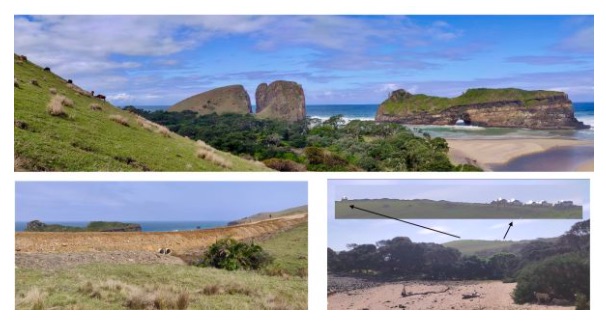
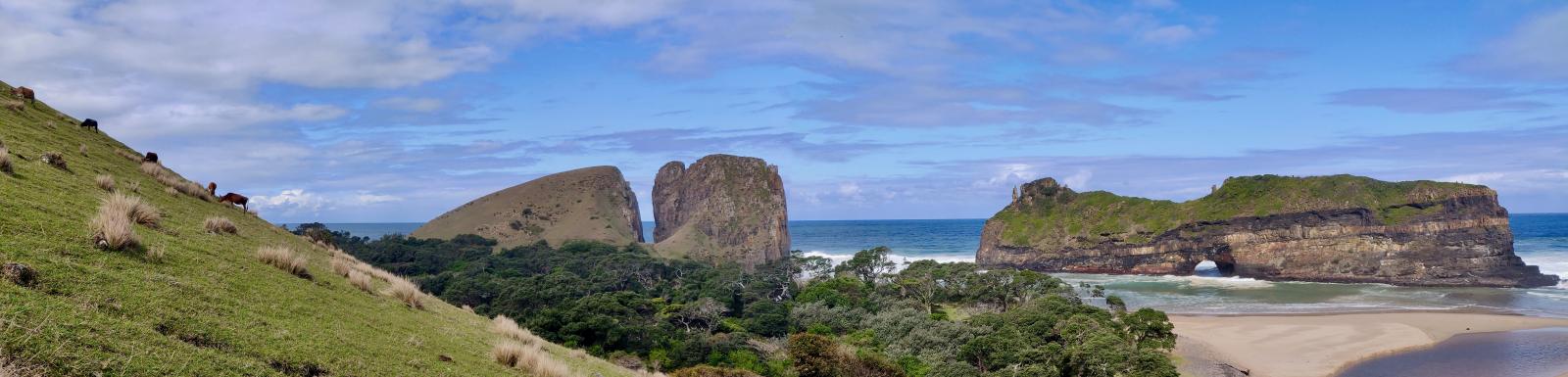
• Preserving the "Sense of Place" at Hole in the Wall:
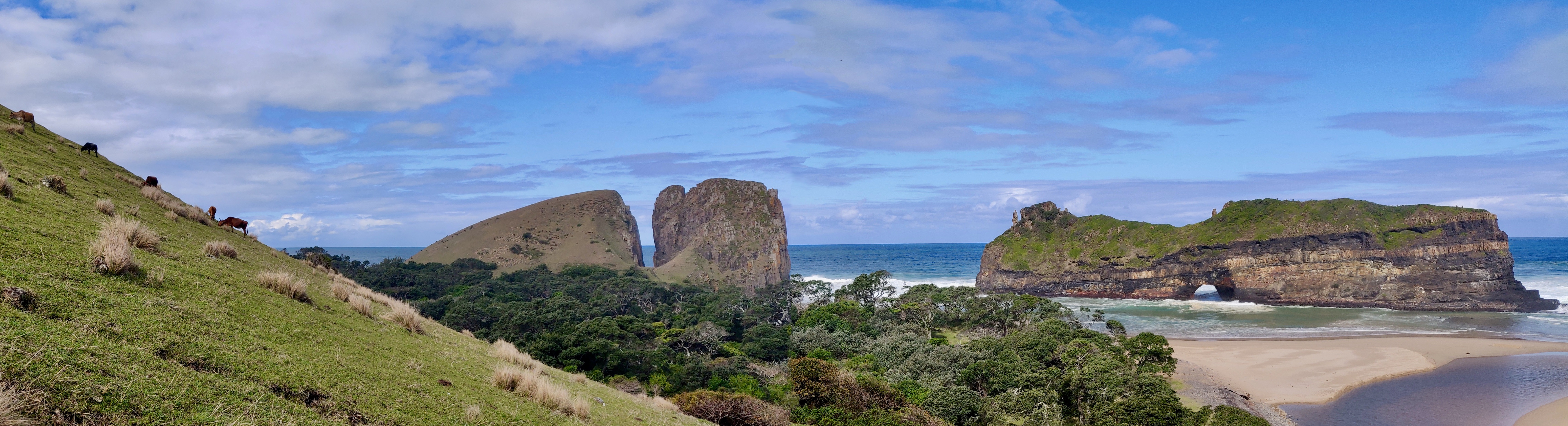
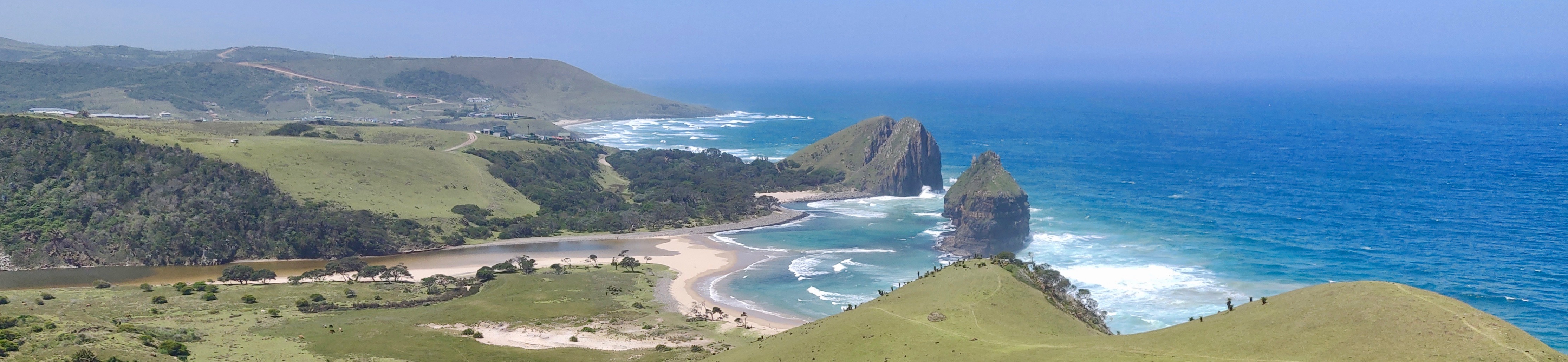
◦ Hole in the Wall is described as one of the "most uniquely beautiful locations on earth" and an "undeclared World Heritage Site of 'Outstanding Universal Value'". Its "Sense of Place" is derived not only from the unique natural arch rock formation but also from the "peaceful surrounds comprising rolling green hills, indigenous milkwood forest, river valley grasslands and the Mpako River itself".
◦ The local municipality's Integrated Development Plan for 2017-2022 explicitly mentions Hole in the Wall as a Heritage Site (though undeclared) no fewer than seven times and warns of the dangers of uncontrolled developments, stating it must be declared a Heritage Site.
◦ Concerns have been raised about the "jarring intrusion" of inappropriate developments, such as the proposed tarred roadway, widened and extended to the hillside overlooking the attraction, impacting the "secluded, peaceful and free natural environment". Such developments would have a "hugely negative socio-economic impact by cheapening and commoditizing the attraction solely for day-tripper busloads and vehicles," providing "zero to very negligible economic benefit to the community" while paving the way for "further inappropriate developments".
◦ Past attempts by the Department of Economic Development, Environment and Tourism (DEDEAT) in 2006 (and approximately 10 years prior) saved this specific hillside from hotel development. An attempt was made a year before the 2019 article to get DEDEAT to demarcate this hillside as a no-go area for development to protect its unspoilt beauty for future generations.
◦ Instead of large-scale developments that "indenture a few locals into wage-slave existence," there is a need for a framework that allows "small scale natural development".
◦ The environmental benefits of keeping the Wild Coast "wild" are acknowledged, and environmentalist groups discourage large-scale interventions like the N2 toll road and titanium mining, supporting the idea of upgrading infrastructure in select destinations without shattering the "wild" idea.
• How Surveying and Tenure Reform can Aid Preservation:
◦ The "highest priority is for development nodes to be surveyed, and all PTOs converted to Freehold in accordance with Act 112 of 1991". This is crucial because "secured ownership can only be achieved through the registration of property boundaries".
◦ Proper surveying would allow for the formalisation of individual land unit boundaries, distinguishing them from communal or public areas like the hillside at Hole in the Wall.
◦ The Upgrading of Land Tenure Rights Amendment Act, 2021 (Act No. 6 of 2021), came into operation on June 1, 2024, explicitly addressing the unconstitutionality of the original ULTRA in former TBVC states (including Transkei) and discriminating against women, thereby providing the legal framework for tenure conversion.
◦ This conversion to freehold, enabled by proper surveying, is seen as key to unlocking "free market principles" and empowering local residents, promoting "bottom-up, reality scaled innovation and entrepreneurship".
◦ While individual PTO holders should have the right to sub-divide and transfer their property, development should be restricted to the nodal model proposed by the Spatial Development Initiative (SDI) and the Wild Coast Tourism Development Policy. This implies that some areas, like the hillside commons, would fall outside these development nodes and remain protected.
◦ The existing 1km Coastal Conservation Area (CCA), carried over from the former Transkei Republic's Environmental Decree 9 of 1993, prohibits development within 1km from the high water mark. While this has prevented some illegal cottages, there is a current lack of control on customary land use and new unplanned dwellings within the CCA. DEDEAT needs to "engage urgently with the local headmen and chiefs to enforce these measures".
◦ Declaring the attraction and its surrounds as a National Heritage Site, with appropriate curation as a Nature Reserve, would create "long-term sustainable benefits for the local community and also minimise as far as possible the inevitable damage to the indigenous forest and surrounds".
In summary, the demand for surveying and tenure upgrading is not just about individual ownership, but also about creating a legal framework that can delineate and protect crucial "commons" like the Hole in the Wall hillside. This protection is essential to maintain the region's environmental integrity, foster sustainable, community-driven tourism, and prevent exploitation and land grabs, aligning with the constitutional mandate for legally secure tenure for all
Failure to act within a reasonable timeframe will leave affected communities with no option but to conclude that the Office of the Land Surveyor General is unwilling to uphold its constitutional obligations. In such an event, we will be compelled to escalate this matter directly to the highest authorities in the country, including initiating further legal action at the Constitutional Court. It is well-established that rural communities have successfully asserted their constitutional land rights in the Constitutional Court, which has consistently ruled against practices that undermine secure tenure and perpetuate apartheid-era structures. We remind you that the Constitution obliges Parliament to ensure legally secure tenure for those dispossessed by past discriminatory laws. The continued withholding of existing individual land rights is immoral, unethical, illegal, and unconstitutional.
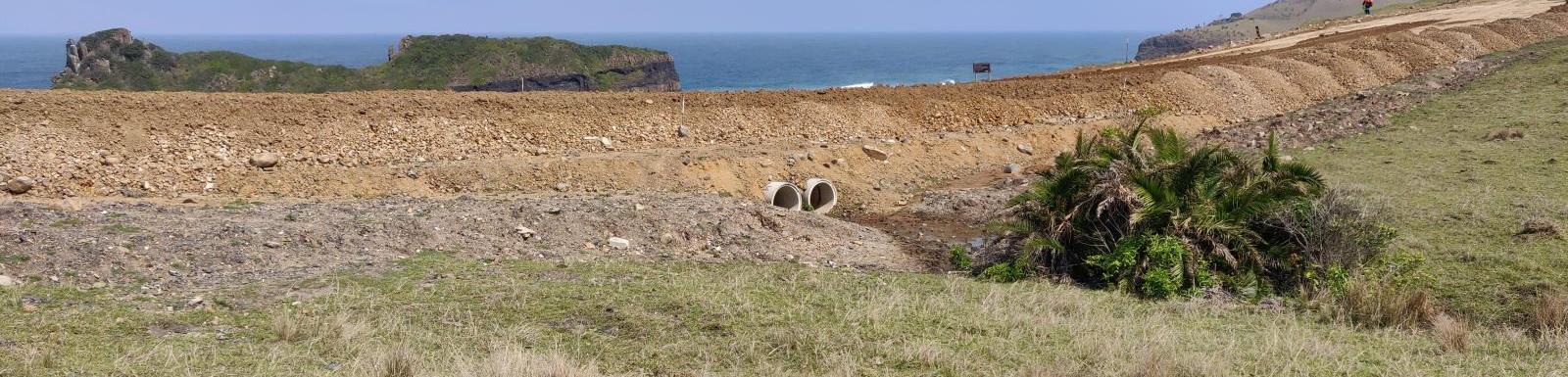
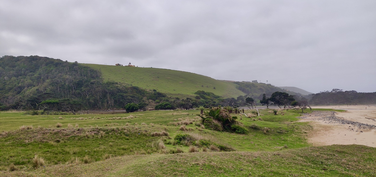
In this picture, you can see where they're busily building the turning circle. They've removed hundreds of cubes of topsoil, and have got to the stage where they return from dumping it with a load of sabunga to replace it, and they're even busy compacting it with a steam roller.
It's also in the approximate region where they think to put the picnic site.
See where the litter is going to irretrievably blow into the pristine cliff forest, river, and out to sea?
The Department of Economic Development, Environment & Tourism (DEDEAT) has approved this ecocidal insanity.
Please click on the link to sign our petition to SAHRA:
South African Heritage Resources Agency 111 Harrington Street CAPE TOWN 8001
For the attention of: SAHRA CEO, SAHRA Council & Chairperson
Dear SAHRA,
URGENT APPLICATION: HOLE IN THE WALL – NATIONAL HERITAGE SITE
Hole in the Wall is one of the most uniquely beautiful locations on earth and yet, while it is unquestionably an undeclared World Heritage Site of “Outstanding Universal Value”, it has unfortunately not yet even been accoladed with National Heritage Site status.
And it is not just the unique natural arch rock formation that is so special, but the peaceful surrounds comprising rolling green hills, indigenous milkwood forest, river valley grasslands and the Mpako River itself, which all contribute to its Sense of Place.
The local municipality’s Integrated Development Plan for 2017 – 2022 mentions no fewer than 7 times that Hole in the Wall is indeed a Heritage Site, but that it is not yet so declared. And it warns of the danger of uncontrolled developments, and goes further to state that it must be declared a Heritage Site.
Unfortunately the Sense of Place is about to be severely and permanently impacted by the inappropriate imposition of a tarred roadway, widened and extended to the edge of the hillside overlooking the attraction, in such a way that vehicles peer over the edge and into the river valley, and are visibly imposed into the setting. Though not yet tarred, this is already especially severe at certain times of the day when the sun’s reflection glares off the windscreens.
Besides the glare, the overwhelming feeling from the vicinity of the Hole in the Wall itself, the nearby beaches and river valley, is of jarring intrusion into what should be a secluded, peaceful and free natural environment, as Nature intended.
Furthermore, the Dept. of Economic Development, Environment & Tourism (DEDEAT) has approved an ill devised notion to situate picnic tables on the grassy area over-looking Hole in the Wall. This is such a terrible idea, as besides further imposition into the setting and degrading the Sense of Place, the hillside is in very close proximity to the river and directly exposed to the prevailing North-East wind, which will cause litter to be blown straight into the river and washed out to sea, and pollute the river valley and cliff forest on either side of the river.
Despite numerous pleas to DEDEAT going back over two years, and a hand-delivered letter from the community to the road contractor’s community liaison officer some two weeks ago, the Department of Transport (DOT) who are carrying out the contract, have ignored the community’s request to meet onsite to discuss the simple mitigation measure of curtailing the roadway, turning circle and parking area by some two hundred metres at the watercourse before the last hillside, and using a far more appropriate, attractive and sheltered location for the picnic site. They stubbornly refuse to hear our pleas, and are hell-bent on their course of senseless destruction.
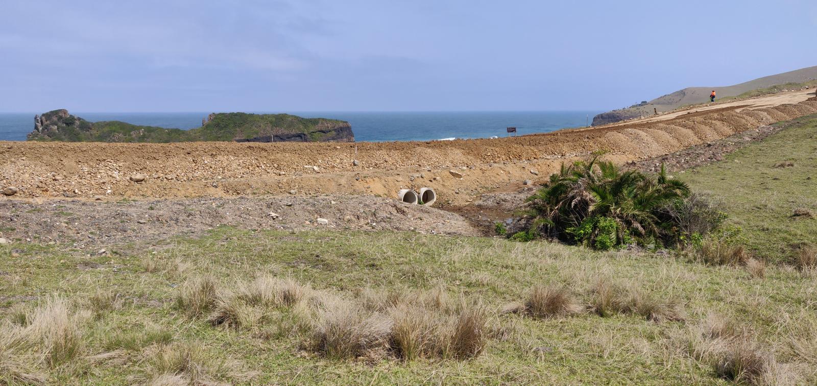
From this location, which is unquestionably the optimal location for the picnic site, they have raised the roadway by some 4 metres and totally impacted the views from all angles. The road should end before the culvert pipes.
This goes beyond even the aesthetic impact, and will also have a hugely negative socio-economic impact by cheapening and commoditizing the attraction solely for day-tripper busloads and vehicles, which would provide zero to very negligible economic benefit to the community, while at the same time paving the way for further inappropriate developments.
Whereas, if the attraction and surrounds are declared a National Heritage Site, and fenced and curated appropriately as a Nature Reserve, with (possibly) a nominal entrance fee (reduced or waived for SA citizens), demarcated nature trails and kayak hire, it will create long-term sustainable benefits for the local community and also minimise as far as possible the inevitable damage to the indigenous forest and surrounds.
As I wrote to the department recently, “the devastating impact can easily be mitigated, while at the same time saving money and providing an invaluable opportunity for creating local employment, whilst also preserving the allure of the attraction’s Sense of Place, seclusion, privacy and freedom.”
In closing I would like to stress that this is a very urgent situation as DOT are planning to complete tarring, and thereby sealing the fate of our beautiful Heritage Site, before the end of the year.
Please let me know if you have any further questions I may answer.
Trusting in your understanding and looking forward to your most urgent response.
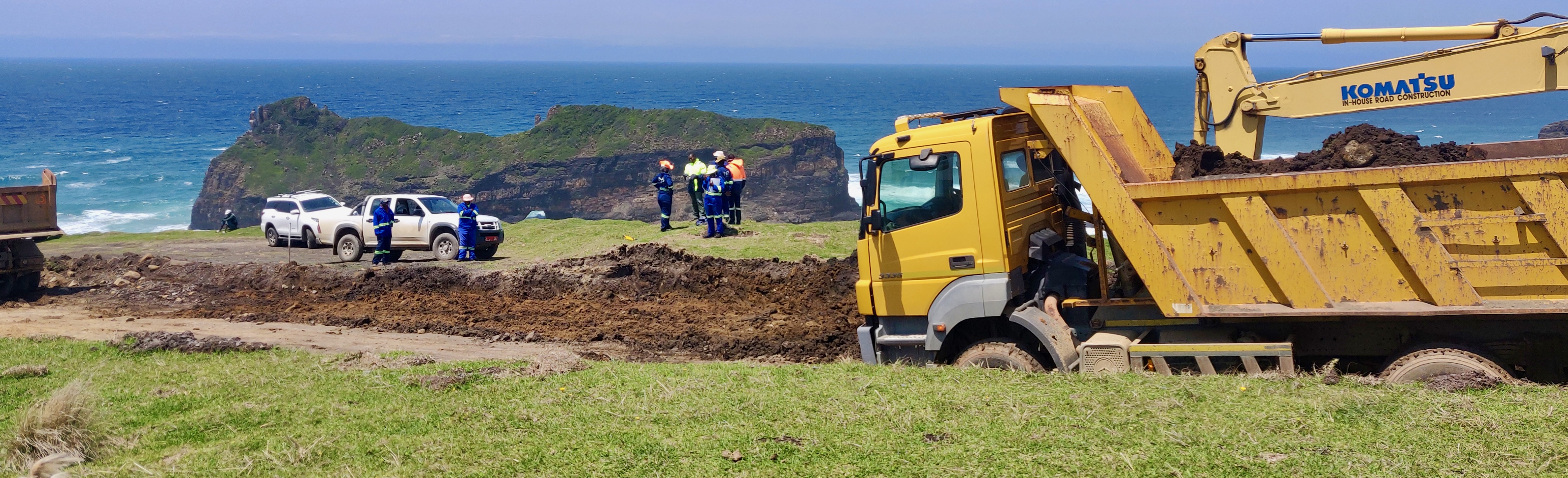
Despite the hand delivered letter two weeks ago, from the community, requesting an onsite meeting with the roads contractor to discuss the wishes of the community, they're busy at work again today. Carting the topsoil away, somewhere, no doubt to replace it with a compacted layer of sabunga prior to tarring...
I guess they believe that if they finish the job in time, all we'll be able to do is accept it.
"Sabunga" is a South Africa colloquial name for a type or variety of sand and / or gravel, from weatherized dolerite. The weathered rock most widely used for road construction in South Africa.
So I phoned Zweliwinile, the "right hand" of Komkhulu, and then went to fetch him. We met with stony indifference from the onsite supervisor, but another meeting has been arranged for tomorrow at our village headwoman's Komkhulu. Following which we'll go to our Tshezi Chief's Komkhulu. The big "Great Place".
For interests sake, the Tshezi are the ruling Bomvana clan of the Jalamba-Gambushe line, with European shipwreck ancestry. They rose to prominence when the Xhosa King Hintsa took Nomsa of the Tshezi's as his Great Wife. The land they occupy in the main is the region around Hole in the Wall and Coffee Bay, whereas Bomvana land extends from the Mbashe River to the Umtata River, and inland some 60km up to Mqanduli.
Some positivity, hopefully: I met Unathi Pali, who is working for Dept. of Transport at the view site itself. He's the firstborn son of our Tshezi Chief, Ngwenyathi. It's some years since I met with Ngwenyathi, but I asked Unathi to please inform his father of the issues and planned mitigations which I tried my best to convey in my broken Xhosa. At the very least I will have made an impression as a mad umlungu raving about the angry "amathongo".
Luisah Teish, author of the book Jambalaya, states "As we walk upon the Earth, our feet press against the bones of the Ancestors on whose shoulders we stand."
These ancestors, going back to antiquity are called Amathongo in Xhosa.
Anyway. My immediate priority today was very much disrupted, and I still have yet to complete the motivation to SAHRA for emergency declaration of Hole in the Wall as a national heritage site. Our best hope for the future of Hole in the Wall.
The current "Integrated Development Plan" for King Sabata Dalindyebo Local Municipality (Link: KSD IDP 2017-2022) mentions no fewer than 7 times that Hole in the Wall is considered a Heritage Site, but that it is not yet proclaimed. And it further warns of the danger of uncontrolled developments.
Yet despite investigating our complaint about the parking lot overlooking the Hole, DEDEAT takes absolutely no cognizance of the disastrous impact on the "Sense of Place" to the surrounds and view site overlooking the Hole in the Wall. Instead, they've sanctioned raising the road level by approximately 4 metres above the watercourse, and widening the roadway to over 15 metres to provide "bus bays" and parking, so that people can enjoy the privilege of seeing the Hole from the comfort of their vehicles. At what cost?
This past Saturday was the busiest day we've seen since March and the lockdown, and at around 15:00 the glare from half a dozen windscreens, alone, was blinding! And the views from the hillside itself are impacted from millions of angles. The "whole" is discarded in favour of a myopic front-row view of the Hole, only.
Dept. of Transport have apparently instructed that this view site be tarred and completed before the new year. But they have yet to complete the actual road leading there. The far more necessary 10km stretch between Coffee Bay and Hole in the Wall has been abandoned for the past two years, after they completed a total of 2,4km of tarring, and left another 1km tarred on one side only. Not to mention the road (DR18031) from Mqanduli to Coffee Bay is in an absolutely appalling state, and should be a FAR higher priority.
Joni Mitchell wrote Big Yellow Taxi in 1969, and it's more relevant today than ever. In her words:
"I wrote Big Yellow Taxi on my first trip to Hawaii. I took a taxi to the hotel and when I woke up the next morning, I threw back the curtains and saw these beautiful green mountains in the distance. Then, I looked down and there was a parking lot as far as the eye could see, and it broke my heart…this blight on paradise."
So anyway, they're tarring the road between Hole in the Wall and Coffee Bay at the moment, and I've been tempted several times to post about the swathe of destruction in its wake for the width of the road and it's graded and cambered 80km /hour specification. (Like, they're cutting 10m or more off the tops of the hills!)
In a tiny little coastal village like this, a sweet little cobblestone road would be far more appropriate, but I couldn't work up the energy to mount a futile protest against the inevitability of it. But when they started working in the village here in Hole in the Wall towards the end of last month, I knew I had to try and do something to prevent them from destroying the "sense of place" and natural beauty of the hillside overlooking Hole in the Wall itself. So I talked to the road crew and they pointed me to their supervisor.
That hillside was saved from development by DEDEAT (Dept. of Economic Development, Environment and Tourism) in 2006, when the new hotel development attempted to site themselves there. There was another development about 10 years ago that they stopped, too. And the investor who had fenced and started building without an EIA or any sort of permission was subsequently forced to remove all traces. He must have lost a lot of money.
Now, however, the spatial development initiative has received funding from national government to fast-track development in this area, so some civil servant has drawn a pen-line from A to B without any thought about environmental and ecological impact; or more to the point, any kind of aesthetic integrity.
A year ago, almost exactly, I mounted an attempt to get DEDEAT to assist with having this particular hillside (and it's counterpart on the other side of the river) demarcated as a no-go area for any development, to protect the environs for future generations to enjoy its unspoilt beauty. The kindly response I got was to the effect that I should try to engage with the community to do so, and they wished me luck. Unfortunately I work for a living, and haven't had the time or resources to undertake such a time-consuming mission. Now it's too late.
They paved paradise And put up a parking lot With a pink hotel, a boutique And a swinging hot spot
Don't it always seem to go That you don't know what you've got til its gone They paved paradise And put up a parking lot
Pretty much everyone will recognise this beautiful cover version by Counting Crows:
Mkambati Nature Reserve, one of five national reserves along the Wild Coast, is to be privatised and made off-limits to all but exclusive paying guests at the proposed resort.
Also, access to the World famous waterfall that falls directly into the Indian Ocean will be restricted to paying guests only. Doesn't seem right.
The Wild Coast has a comparatively high average rainfall, with the coastal belt receiving over 1000mm per annum. Spring rains generally appear in October, with July to September being the coolest and dryest months of the year; and December to February being the hottest and wettest.
Temperatures can vary considerably between the northern and southern parts of the Wild Coast, with around a 1° C average increase per 100km as one moves northwards towards the sub-tropics. Whereas Port St Johns, for example, has heavy, hot and humid summer months similar to Durban and the South Coast; Coffee Bay down past Hole in the Wall and the south enjoy far milder and more temperate climes.
Overall the Wild Coast enjoys very temperate climes with comfortable sub-tropical temperatures along most of the coast in summer, averaging around 23° during the day, and about 18°C at night.
The summer rainy seasons are sub tropically warm and pleasant, while the winters are mild and fine. The Wild Coast thus makes a great getaway for frost-bitten inland residents during the mid-winter school holidays. (July also coincides with the sardine run, lots of whale and dolphin activity, and the aloes and corral trees in full flaming bloom.)
Mid Wild Coast (Hole in the Wall) highs in January (mid summer) reach about 28°C , and in June (winter) about 21°C; with lows of 17°C and 10°C respectively. The mid-winter temps are typically balmy with daytime temperatures around 18°C and falling to an average of around 14°C at night.
Prevailing winds are from the North East and South West, with a distinct tendency for the N-E to dominate. Wind speeds on a good blowy day can gust around 50km/hr. Generally, mid-winter months have less wind.
I commented recently about the cabinet ministry changes, and made a similar comment about Buyelwa Sonjica (who is now Minister of Water and Environmental Affairs) and her obvious pro-industrialization inclinations, so I think it's fairly appropriate to post Tonie Carnie's article published in The Mercury on 13 May 2009.
UPDATE 24 November 2021: This original 2007 article, Save the Wild Coast Campaign was an initiative which subsequently changed its name to Sustaining the Wild Coast (SWC), and the issues, while ongoing, are not related to the proposed Shell and Impact Africa seismic surveys of December 2021:
Threatened nature in South Africa
Please support the international "Save the Wild Coast Campaign" by sending a letter or fax to the South African President, Thabo Mbeki and the Minister for the Environment, Marthinus van Schalkwyk.
The Pondoland centre of endemism is located in the Eastern Cape Province on the shores of the Indian Ocean of South Africa. The Pondoland Centre, as part of the Maputaland-Pondoland Region, has subsequently been acknowledged as one of the important centres of plant diversity and endemism in Africa. The area is the smallest of the 18 centres of endemism and boasts 1,800 plant species.
Late in 2004, Washington-based "Conservation International" published the book "Hotspots Revisited" in which 34 " Hotspots" are identified as "Earth’s Biologically Richest and Most Endangered Ecoregions". One of the newly added Hotspots is the Maputaland-Pondoland Region. The Pondoland Centre is the smallest and the most vulnerable.
There are 39 European Migratory birds found in the area to be impacted upon by the proposed Toll Road. Two species are globally threatened: the White Stork (Ciconia ciconia) and the Corncrake (Crex crex) while one species is globally near threatened: the Lesser Kestrel (Falco naumanii).
South Africa is signatory to the Convention on Biological Biodiversity. Article 6 of the convention provides for General Measures for Conservation and Sustainable Use and requires contracting parties to develop national strategies, plans and programmes for the conservation and sustainable use of biological diversity and to integrate these as far as possible into relevant sectoral programmes. Currently South Africa has developed the National Biodiversity Strategic Action Plan as part of the obligations to the Convention on Biological Biodiversity.
South Africa is also a signatory to the Convention of Migratory Species of Wild Animals. The primary objective of the Convention is accordingly to protect migratory species. One of the objectives is to encourage "range states" to conclude agreements for the conservation and management of species listed in appendix 2 of the Convention.
In 2002 the South African National Roads Agency Ltd, accepted an unsolicited bid by a construction consortium to construct a Toll Road from East London in the Eastern Cape to Port Edward in Kwa-Zulu Natal. Currently 85% of the existing road is being upgraded.
The construction consortium has proposed to develop a new section of road "Green fields" between Lusiksiki and Port Edward (85 kilometres in length). This section of road will traverse through the Pondoland Centre of Endemism, thus impacting on area that has been internationally recognized as a "Global Hotspot" for flora and fauna.
The South African Minister of the Department of Environmental Affairs and Tourism, Minister van Schalkwyk, announced on the 31st August 2005 that an agreement between the Eastern Cape Department of Nature Conservation and the National Department had been reached to create the Pondoland National Park. The Minister was however, extremely vague as to where the boundaries of the proposed Pondoland Park would be.
The "Save the Wild Coast Campaign" has welcomed this commitment, however the Minister has declined to confirm whether this will exclude the construction of the controversial 85 kilometres of road through the Pondoland Centre of Endemism as well as a proposed titanium strip-mining application along the 220 kilometres of pristine coastline. Word in the house of Parliament is that the road will proceed in spite of the fact it will travel through the area that should be set aside as a National Park.
The "Save the Wild Coast Campaign" has led an advocacy and lobbying campaign to re-route the "Greenfields" section of the road to a section known as the R61 which travels in close proximity to many towns and settlements. This option would benefit many thousands of inhabitants and be a sustainable option in terms of poverty alleviation and sustainable job creation, while ensuring the protection of a globally recognized hotspot and access to intergenerational equity.
The SWC require international support for this advocacy to ensure that South Africa honours its commitment as signatories to The Convention on Biodiversity and The Convention of Migratory Species of Wild Animals.
International support for this measure addressed to the National Minister, Minister van Schalkwyk would give impetus to the campaign and ensure South Africa’s accountability to international obligations.
If there are any questions please contact the "Save the Wild Coast" campaign directly:
The Wild Coast Campaign PO Box 52 Port Shepstone Kwa-Zulu Natal 4240 South Africa

 Besides the glare, the overwhelming feeling from the vicinity of the Hole in the Wall itself, the nearby beaches and river valley, is of jarring intrusion into what should be a secluded, peaceful and free natural environment, as Nature intended.